Sunday, November 20, 2011
PLSS map
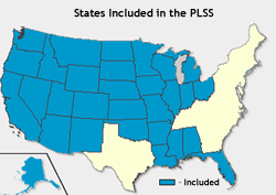
A PLSS map or (public land survey system) is a system of mapping the land in the United States by dividing it up into rectangular blocks. The U.S. Department of the interior and the Bureau of Land Management first designed this system as why to divide up federally owned lands. This map is a basic PLSS map and shows a fundamental PLSS map.This PLSS map shows the states included in the PLSS.
Subscribe to:
Post Comments (Atom)
No comments:
Post a Comment